This thread is used for any mobsters to travel around the Map to reach various places. Please read the rules to travel below.
RULES FOR TRAVELLING SYSTEM
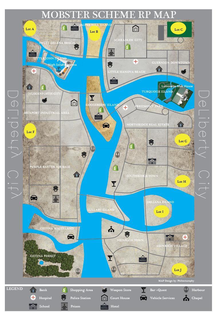
Calculating Distance in MAP and How it Affects the SCHEME and MOB WAR
1. Grid view of the map is used to check the distance between one place to another. You can count how many squares away from a place to another.
2. The counting should be done in a non-diagonal way using only horizontal and vertical movement. [eg: from Luminaire house to Bar at 6P is approximately 10 grids away, using the road from Little Hanova Beach])
3. Also the counting should follows the path of the road.
4. The distance will determine the timing of the SCHEME and MOB WAR to occur using hours. (For instance: if Mob A 8 squares away from the Location and Mob B 10 squares away, then Mob A can start the SCHEME [(10-8)*X] hours or 2X hours earlier than MOB B. Here X is the value depends on the type of vehicle you use. The faster the vehicle, X would be smaller so that in this case Mob A will arrive earlier than Mob B. This may allows them to have advantage of setting Traps and all if they knew that Mob B will arrive soon)
RULES TO BE ABLE TO TRAVEL
1. If you are still a subordinates in a Mob, you must ask permission from your Boss in order for you to be able to travel outside the Mob House.
2. You can ask permission in any SCHEME you are in whenever you feel that you have finish your part over there.
3. Certainly you can also go out to travel around if your boss allows you too.
4. You need time to go to one place from another. The time required for you to travel depends on your TRAVELLING METHOD.
5. Realistically, you cannot obviously be at two place at the same time.
6. If you are in one place, then your boss phone you to go back, you need time to travel back.
TRAVELLING METHODS
1. Walking: each square grid is traveled by 12 hour. (eg: from 12M to 9L is 4*12=48 hours walking distance)
2. Vehicle: each square grid is traveled by X hour, in which the value of X depends on the type of the car.
EXACT LOCATION AT MAP BASED ON GEOGRAPHY
GUERNSON DOWNTOWN: Bank 11R ll Weapon Store 13R ll
SCHRADLER CITY: Courthouse 9V ll Shopping Area 9T ll Prison 7T ll Lot C 12U
LITTLE HANOVA BEACH: Police Station 7S ll Hotel 7Q ll Hospital 9S
JASSPER HILL ISLAND: Lot B 6U
SWEET HELENA BEACH: Police Station 5T ll Hotel 5V ll Shopping Area 4V ll Lot A 2V
LITTLE JOHN ISLAND: High Society Marina 4S ll Harbour 3R ll Hotel 1S
HUDSENFORTH CITY: Hospital 2R ll Bank 1Q ll Shopping Area 2Q ll Weapons Store 2P
BRIXPORT INDUSTRIAL AREA: CourtHouse 5O ll Lot F 2M
PURPLE BAXTER AIRBASE: Harbour 6Kll Police Station 5K 3Hll Bank 5I ll Prison 3G ll Vehicle Service 1G
CISTINA WASTELAND: Vehicle Service 5D
HEINRICH TOWN: Chapel 8E ll Police Station 9D ll Bar 8B ll Harbour 8A ll Hotel 10B
HEINRICH VILLAGE: School 12D ll Hospital 13D ll Lot J 13B
DELIANA ISLAND: Lot I 10F
SOUTHRIDGE TOWN: Bar 8I ll Shoppin Area 8J 9L ll Lot H 12I ll Lot G 12L ll School 10 J ll Police Station 10L ll Harbour 8K
NORTHRIDGE REAL ESTATE: Bank 12M ll Hospital 8O
TURQUOISE ISLAND: Mob House Luminaire 12P
GOOSEBERRY ISLAND: Vehicle Services 7N ll Hotel 6N ll Shopping Area 7O ll Bar 6P
FORMAT FOR TRAVELLING Your mobster name: Mob you belong to: Your current mobster rank: (Check HERE)
Your current money: (Check HERE) Travelling method: (Walking / Vehicle if you have any / Boat if you are using the service) Your current location in the Map: [eg: Luminaire Mob House 12P]) Where do you want to go: (Name the place and the Grid, [eg: Bar at Grid: 6P]) Describe the roads you take to travel and mention How many squares away the distance between your current location and the place you want to visit: (Calculating the distance based on the Above Travelling Rules. The admins will double check your approximation) [eg: 10 grids away, I use the road that pass the Little Hanova Beach]) Your money after travelling: (If later on you decide to travel by public vehicles such as boat, your money will be charged. But travelling by walking is free)